For all geometries of aeronautical features a coordinate reference systems (CRS) must be specified. The CRS reference is critical for the correct encoding and processing of AIXM geometries. Without a known CRS, coordinates in the descriptions of a geometry have little meaning.
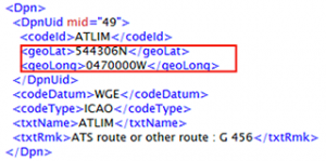
In AIXM 4.5 the proprietary element codeDatum is used to provide information about the relevant CRS of the data. It is directly related to the feature. An AIXM 4.5 specific code list is used for codeDatum, e.g. “WGE” stands for WGS 84.

For AIXM 5, the GML defined attribute srsName is applied to define the CRS. srsName allows to reference CRS standard codes defined by international organisations. In case of WGS 84, for the encoding of aeronautical data in AIXM 5 it is recommended to use the code “EPSG 4326[1]” (it is the WGS 84 reference datum required by ICAO with latitude/longitude axis order). Note that there are more than one definition for a WGS-84 based CRS, e.g. “OGC CRS84[2]” is a variant of EPSG 4326 (differing only in its coordinate order: longitude before latitude). There are also other EPSG codes representing WGS 84 (depending on its type e.g. 3D or 2D or a projection, area of applications, etc.) The example below shows the encoding of the same position (an ARP) applying different WGS 84 definitions.


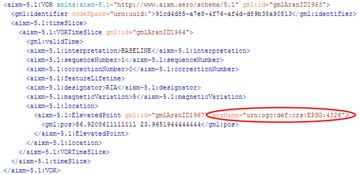
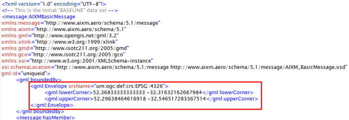
Applying GML, the CRS is either defined directly on the geometry element, or it is derived from the larger context this geometry is part of (gml:Envelope). The image below shows an example of the CRS encoded directly with the concerned feature (in this case a VOR).

The Envelope element provides the overall spatial extent of a feature collection (AIXM 5 message) as a bounding box. The first direct position is the “lower corner” the second one the “upper corner“. The srsName attribute on the gml:Envelope is inherited by all directly expressed geometries in all properties of all the members of the feature collection (AIXM 5 message), unless overruled by the presence of a local srsName (i.e. defined directly within the feature).

[1] The European Petroleum Survey Group (EPSG) registry (http://www.epsg-registry.org/) is the traditional source of CRS definitions. Most GIS systems use EPSG codes to refer to CRS definitions.
[2] The Open Geospatial Consortium (OGC) maintains a registry of CRS URIs at http://www.opengis.net/def/crs. Within that space, EPSG CRS definitions can be looked up and referenced to GML descriptions of the CRS. The OGC also serves its own CRSs.
Leave a Reply